Fichier:Cyclone Nargis flooding before-and-after.jpg

Fichier d’origine (540 × 712 pixels, taille du fichier : 137 kio, type MIME : image/jpeg)
Ce fichier provient de Wikimedia Commons.
Les informations le concernant sont affichées dans cette page de description qui est copiée ci-dessous.
Commons est un serveur de fichiers sous licence libre. Vous pouvez aider (procédure). |

Description
| Description |
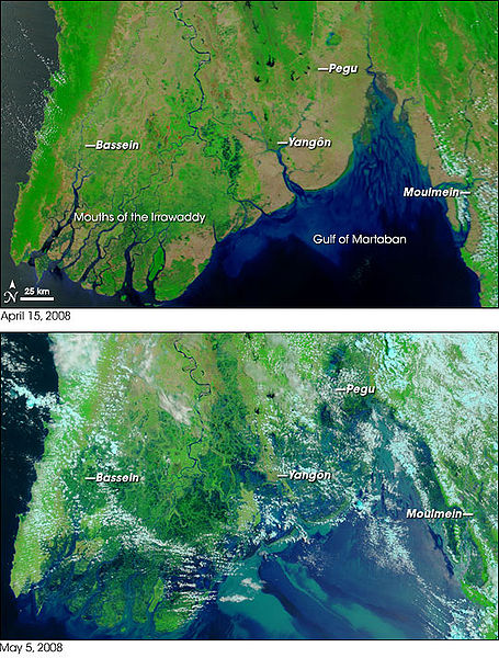
Satellite photos from NASA's w:Terra satellite, showing part of w:Burma/(Myanmar) on April 15, 2008 (top) and May 5, 2008 (bottom), resulting in before-and-after comparisons of the impact from w:Cyclone Nargis. The first cyclone of the 2008 season in the northern Indian Ocean was a devastating one for Myanmar (Burma). According to reports from Accuweather.com, Cyclone Nargis made landfall with sustained winds of 130 mph and gusts of 150-160 mph, which is the equivalent of a strong Category 3 or minimal Category 4 hurricane. News reports stated that at least 10,000 people were killed, and thousands more were missing as of May 5. Flood water can be difficult to see in photo-like satellite images, particularly when the water is muddy. This pair of images from the Moderate Resolution Imaging Spectroradiometer (MODIS) on NASA’s Terra satellite use a combination of visible and infrared light to make floodwaters obvious. Water is blue or nearly black, vegetation is bright green, bare ground is tan, and clouds are white or light blue. On April 15 (top), rivers and lakes are sharply defined against a backdrop of vegetation and fallow agricultural land. The Irrawaddy River flows south through the left-hand side of the image, splitting into numerous distributaries known as the Mouths of the Irrawaddy. The wetlands near the shore are a deep blue green. Cyclone Nargis came ashore across the Mouths of the Irrawaddy and followed the coastline northeast. The entire coastal plain is flooded in the May 5 image (bottom). The fallow agricultural areas appear to have been especially hard hit. For example, Yangôn (population over 4 million) is almost completely surrounded by floods. Several large cities (population 100,000–500,000) are in the affected area. Muddy runoff colors the Gulf of Martaban turquoise. The high-resolution image provided above is at MODIS’ maximum spatial resolution (level of detail) of 250 meters per pixel. The MODIS Rapid Response Team provides twice-daily images of the region in additional resolutions and formats, including photo-like natural color. NASA images courtesy the MODIS Rapid Response Team. Caption by Rebecca Lindsey. References:
|
|||||
| Date | ||||||
| Source | NASA Earth Observatory | |||||
| Auteur | MODIS Rapid Response Project at NASA/GSFC | |||||
| Autorisation (Réutilisation de ce fichier) |
|
|||||
| Autres versions |
Œuvres dérivées de ce fichier : Cyclone Nargis flooding before-and-after (Gif).gif none |
.gif)
Conditions d’utilisation
| Ce fichier provient de la NASA. Sauf exception, les documents créés par la NASA ne sont pas soumis à copyright. Pour plus d'informations, voir la politique de copyright de la NASA. | ||
 |
Attention :
|
Historique du fichier
Cliquer sur une date et heure pour voir le fichier tel qu'il était à ce moment-là.
| Date et heure | Vignette | Dimensions | Utilisateur | Commentaire | |
|---|---|---|---|---|---|
| actuel | 6 mai 2008 à 01:52 | | 540 × 712 (137 kio) | Miss Madeline~commonswiki | {{Information |Description=Satellite photos from NASA's w:Terra satellite, showing part of w:Burma/(Myanmar) on April 15, 2008 (top) and May 5, 2008 (bottom), resulting in before-and-after comparisons of the impact from w:Cyclone Nargis. |Sour |
Utilisation du fichier
La page suivante utilise ce fichier :
Usage global du fichier
Les autres wikis suivants utilisent ce fichier :
- Utilisation sur bn.wikipedia.org
- Utilisation sur ca.wikipedia.org
- Utilisation sur cy.wikipedia.org
- Utilisation sur de.wikipedia.org
- Utilisation sur de.wikinews.org
- Utilisation sur en.wikipedia.org
- Utilisation sur en.wikinews.org
- Utilisation sur es.wikipedia.org
- Utilisation sur fr.wikipedia.org
- Utilisation sur it.wikipedia.org
- Utilisation sur ko.wikipedia.org
- Utilisation sur la.wikipedia.org
- Utilisation sur my.wikipedia.org
- Utilisation sur nl.wikipedia.org
- Utilisation sur no.wikipedia.org
- Utilisation sur pl.wikipedia.org
- Utilisation sur pt.wikipedia.org
- Utilisation sur ru.wikipedia.org
- Utilisation sur sco.wikipedia.org
- Utilisation sur simple.wikipedia.org
- Utilisation sur si.wikipedia.org
- Utilisation sur sv.wikipedia.org
- Utilisation sur sv.wikinews.org
- Utilisation sur th.wikipedia.org
- Utilisation sur uk.wikipedia.org
- Utilisation sur vi.wikipedia.org
- Utilisation sur www.wikidata.org
- Utilisation sur zh.wikipedia.org