Fichier:Walloon Region in Belgium and Europe.svg

Taille de cet aperçu PNG pour ce fichier SVG : 680 × 520 pixels. Autres résolutions : 314 × 240 pixels | 628 × 480 pixels | 1 004 × 768 pixels | 1 280 × 979 pixels | 2 560 × 1 958 pixels.
Fichier d’origine (Fichier SVG, nominalement de 680 × 520 pixels, taille : 2,36 Mio)
Ce fichier provient de Wikimedia Commons.
Les informations le concernant sont affichées dans cette page de description qui est copiée ci-dessous.
Commons est un serveur de fichiers sous licence libre. Vous pouvez aider (procédure). |

Description
| Description |
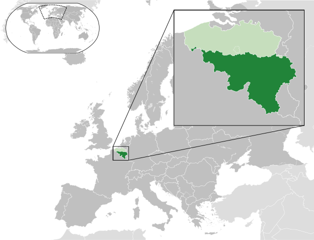
English: A map of the Walloon Region within Belgium and within Europe. |
| Date | (UTC) |
| Source |
Ce fichier est dérivé de : Blank map of Europe (with disputed regions).svg: |
| Auteur |
|
| Autres versions |
|


.svg)
Conditions d’utilisation
Ce fichier est disponible selon les termes de la licence Creative Commons Attribution – Partage dans les Mêmes Conditions 3.0 (non transposée).
- Vous êtes libre :
- de partager – de copier, distribuer et transmettre cette œuvre
- d’adapter – de modifier cette œuvre
- Sous les conditions suivantes :
- paternité – Vous devez donner les informations appropriées concernant l'auteur, fournir un lien vers la licence et indiquer si des modifications ont été faites. Vous pouvez faire cela par tout moyen raisonnable, mais en aucune façon suggérant que l’auteur vous soutient ou approuve l’utilisation que vous en faites.
- partage à l’identique – Si vous modifiez, transformez, ou vous basez sur cette œuvre, vous devez distribuer votre contribution sous la même licence ou une licence compatible avec celle de l’original.
Journal des téléversements d’origine
This image is a derivative work of the following images:
- File:Blank_map_of_Europe.svg licensed with Cc-by-sa-2.5
- 2012-02-21T16:27:27Z Alphathon 680x520 (614699 Bytes) Updated Metadata and the boarders/coastlines along the western coast of the Black Sea
- 2011-09-19T22:57:58Z Alphathon 680x520 (603759 Bytes) Added North/Northern Cyprus
- 2011-08-23T10:26:48Z Heb 680x520 (604212 Bytes) Added [[:en:Bornholm]] (taken from [[:File:Denmark blank map.svg]])
- 2011-04-12T00:40:40Z Alphathon 680x520 (602549 Bytes) Upgraded Sicily based on "File:Freeworldmaps-sicily.jpg". Upgraded Malta based on "File:Map of Malta 2.png". Simplified Croatian borders.
- 2011-04-10T21:43:04Z Alphathon 680x520 (607359 Bytes) Upgraded Croatia, Bosnia & Herzegovina, Slovenia and surrounding countries based on data from "File:Kroatien - Politische Gliederung (Karte).png"
- 2011-04-10T20:05:09Z Alphathon 680x520 (568373 Bytes) Improved Serbia, Montenegro and surrounding countries using data from "File:Serbia Map.png". Fixed Serbia-Montenegro border. Added Kosovo (using dashed border, since it is not a universally recognised nation, and left the lan
- 2011-04-10T15:55:02Z Alphathon 680x520 (524980 Bytes) Tweaked Ukraine and surrounding countries based on data from "File:Up-map.png"
- 2011-04-10T04:02:09Z Alphathon 680x520 (511168 Bytes) Improved Greece, Albania, F.Y.R. Macedonia and Bulgaria based on "File:Greece topo.jpg"
- 2011-04-10T02:48:52Z Alphathon 680x520 (505569 Bytes) Tweaked Germany and surrounding countries based on info from "File:Germany_general_map.png"
- 2011-04-10T01:54:05Z Alphathon 680x520 (493733 Bytes) Converted all lakes back to separate layer. Added Finish lakes and tweaked Finland shape based on "File:Finland 1996 CIA map.jpg". Added Swiss lakes based on "File:Suisse cantons.svg". Tweaked Scotland and added Lochs.
- 2011-04-10T00:07:54Z Alphathon 680x520 (450120 Bytes) Improved England outline and added Isle of Wight based on "File:England Regions - Blank.svg". Improved Denmark based on "File:2 digit postcode danmark.png". Improved Sweden based on "File:Map of Sweden, CIA, 1996.jpg"
- 2011-04-08T15:53:07Z Alphathon 680x520 (438878 Bytes) Upgraded/fixed various parts of the map. Details: *Some minor fixes to Ireland and added some of the larger lakes based on [[:File:Ireland_trad_counties_named.svg]] *Pretty major fixes to Scotland (mainly the west coast and i
- 2008-09-17T09:50:25Z F7 680x520 (531491 Bytes)
- 2008-09-17T09:42:57Z F7 680x520 (2353 Bytes)
- 2008-05-26T19:04:07Z Collard 680x520 (531491 Bytes) uploading on behalf of [[User:Checkit]], direct complaints to him plox: 'Moved countries out of the "outlines" group, removed "outlines" style class, remove separate style information for Russia'
- 2008-04-30T01:38:52Z TimothyBourke 680x520 (531767 Bytes) Changed the country code of Serbia to RS per [http://en.wikipedia.org/wiki/Serbian_country_codes] and the file [http://www.iso.org/iso/iso3166_en_code_lists.txt].
- 2008-02-08T22:44:37Z CarolSpears 680x520 (531767 Bytes) validated
- 2007-07-10T11:47:59Z MrWeeble 680x520 (533112 Bytes) Updated to include British Crown Dependencies as seperate entities and regroup them as "British Islands", with some simplifications to the XML and CSS
- 2007-05-14T17:17:34Z Zirland 680x520 (540659 Bytes) serbia and montenegro
- 2007-03-30T20:40:49Z W!B: 680x520 (538830 Bytes) minor corr: update nl:Ijsselmeer, del fi:lakes (all small), add ru:lake Oneka (all ref maps.google), glued northern irland back to ie ;)
- 2007-02-05T18:44:32Z Maix 680x520 (538295 Bytes) cropped
- 2007-02-04T15:07:29Z Maix 680x520 (538310 Bytes) {{Information |Description=A blank Map of Europe in SVG format. Every country has an id which is its ISO-3116-1-ALPHA2 code in lower case for easy coloring. |Source=Image based on [[Image:Europe_countries.svg|]] by [[User:Ti
Téléversé avec derivativeFX
Historique du fichier
Cliquer sur une date et heure pour voir le fichier tel qu'il était à ce moment-là.
| Date et heure | Vignette | Dimensions | Utilisateur | Commentaire | |
|---|---|---|---|---|---|
| actuel | 22 décembre 2023 à 11:23 | | 680 × 520 (2,36 Mio) | Iktsokh | Cyprus geographically in Asia |
| 21 mars 2021 à 09:29 |  | 680 × 520 (2,36 Mio) | MrLune | Reverted to version as of 20:09, 17 August 2013 (UTC) it is in europe | |
| 19 février 2015 à 20:23 |  | 680 × 520 (2,37 Mio) | Leftcry | Cyprus isn't Europe | |
| 17 août 2013 à 20:09 |  | 680 × 520 (2,36 Mio) | Alphathon | Enlarged zoomed-in map | |
| 28 juillet 2013 à 15:33 |  | 680 × 520 (2,36 Mio) | Alphathon | == {{int:filedesc}} == {{Information |Description={{en|A map of the Walloon Region within Belgium and within Europe.}} |Source={{Derived from|Blank_map_of_Europe.svg|display=50}} |Date=2013-07-28 14:55 (UTC) |Author=*File:Blank_map_of_Europe.svg:... |
Utilisation du fichier
La page suivante utilise ce fichier :
Usage global du fichier
Les autres wikis suivants utilisent ce fichier :
- Utilisation sur af.wikipedia.org
- Utilisation sur an.wikipedia.org
- Utilisation sur be.wikipedia.org
- Utilisation sur bs.wikipedia.org
- Utilisation sur cy.wikipedia.org
- Utilisation sur en.wikipedia.org
- Utilisation sur es.wikipedia.org
- Utilisation sur eu.wikipedia.org
- Utilisation sur fa.wikipedia.org
- Utilisation sur fi.wikipedia.org
- Utilisation sur fr.wikipedia.org
- Utilisation sur fy.wikipedia.org
- Utilisation sur gd.wiktionary.org
- Utilisation sur hr.wikipedia.org
- Utilisation sur hu.wikipedia.org
- Utilisation sur id.wikipedia.org
- Utilisation sur incubator.wikimedia.org
- Utilisation sur is.wikipedia.org
- Utilisation sur ja.wikipedia.org
- Utilisation sur ka.wikipedia.org
- Utilisation sur ko.wikipedia.org
- Utilisation sur li.wiktionary.org
- Utilisation sur lv.wikipedia.org
- Utilisation sur mk.wikipedia.org
- Utilisation sur nl.wikipedia.org
- Utilisation sur nl.wikinews.org
- Utilisation sur nrm.wikipedia.org
- Utilisation sur oc.wikipedia.org
- Utilisation sur pcd.wikipedia.org
- Utilisation sur pl.wikipedia.org
- Utilisation sur pl.wikivoyage.org
- Utilisation sur pnb.wikipedia.org
- Utilisation sur ro.wikivoyage.org
- Utilisation sur sco.wikipedia.org
- Utilisation sur simple.wikipedia.org
- Utilisation sur sl.wikipedia.org
- Utilisation sur ta.wikipedia.org
- Utilisation sur th.wikipedia.org
- Utilisation sur tl.wikipedia.org
- Utilisation sur tr.wikipedia.org
- Utilisation sur ur.wikipedia.org
- Utilisation sur vi.wikipedia.org
- Utilisation sur zh-yue.wikipedia.org
- Utilisation sur zh.wikipedia.org
Voir davantage sur l’utilisation globale de ce fichier.